Green Hill night lights from space
Night Light of Green Hill (Tennessee) from space (United States) Src. Average luminocity for 10x10km area is 71.2727% and for 50x50km: 53.6311%.
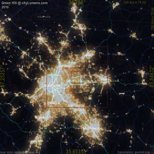
Analysis of Green Hill night lights 2016
Square area 10x10 km:
 5.07%
5.07%90-99
8.39%80-89
18.88%70-79
15.56%60-69
33.74%50-59
11.89%40-49
2.62%30-39
3.67%20-29
0.17%10-19
0%0-9
0%Square area 50x50 km:
11.42%90-99
10.59%80-89
8.62%70-79
8.85%60-69
8.21%50-59
5.94%40-49
5.97%30-39
7.35%20-29
10.33%10-19
10.44%0-9
12.29%Clear (daylight) street map image can be seen on geolist.org.
Map coordinates:
36° 47' 16.8" North, 87° 15' 9.3" West
36° 13' 22.2" North, 86° 32' 58" West
35° 39' 12.8" North, 85° 50' 46.8" West
Some cities around Green Hill sort by population:
• Nashville
22 km =13.7 mi,  253°
253°
• Hendersonville
11.1 km =6.9 mi,  325°
325°
• La Vergne
23.2 km =14.4 mi,  187°
187°
• Gallatin
20.6 km =12.8 mi,  26°
26°
• Mount Juliet
3.8 km =2.4 mi,  132°
132°
• Lebanon
23.2 km =14.4 mi,  94°
94°
• Goodlettsville
18.4 km =11.4 mi,  307°
307°
• Millersville
21.9 km =13.6 mi,  318°
318°
4626181 (p: 6,618)
Sources (retrieved 2019-11-25):
» Earth at Night: Flat Maps 2012, 2016