Frankenmuth night lights from space
Night Light of Frankenmuth (Michigan) from space (United States) Src. Average luminocity for 10x10km area is 9.7984% and for 50x50km: 9.9574%.
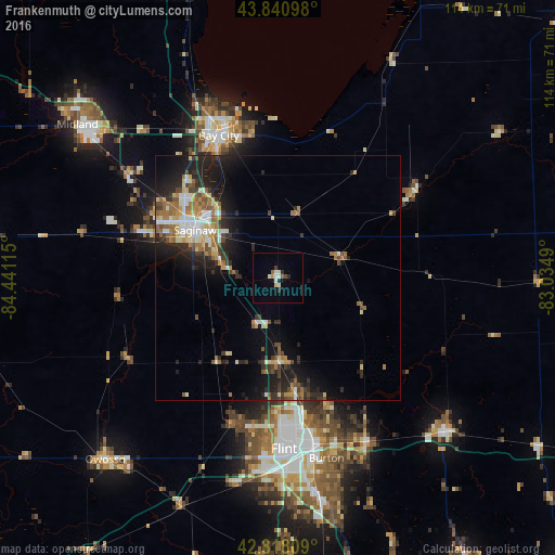
Analysis of Frankenmuth night lights 2016
Square area 10x10 km:
 1.43%
1.43%90-99
2.22%80-89
1.43%70-79
0.63%60-69
0.48%50-59
0.79%40-49
0.95%30-39
0.48%20-29
2.38%10-19
0%0-9
89.21%Square area 50x50 km:
1.2%90-99
1.52%80-89
1.24%70-79
1.02%60-69
1.7%50-59
1.4%40-49
1.21%30-39
1.51%20-29
3.62%10-19
6.13%0-9
79.45%Clear (daylight) street map image can be seen on geolist.org.
Map coordinates:
43° 50' 27.5" North, 84° 26' 28.1" West
43° 19' 54.1" North, 83° 44' 16.9" West
42° 49' 5.1" North, 83° 2' 5.6" West
Some cities around Frankenmuth sort by population:
• Saginaw
19.8 km =12.3 mi,  299°
299°
• Saginaw Township North
26 km =16.2 mi, 303°
• Beecher
27.1 km =16.8 mi,  172°
172°
• Flushing
31.2 km =19.4 mi,  197°
197°
• Bridgeport
12 km =7.5 mi,  284°
284°
• Buena Vista
16.3 km =10.1 mi,  307°
307°
• Shields
27.4 km =17 mi,  289°
289°
• Carrollton
21 km =13 mi, 312°
4993321 (p: 5,025)
Sources (retrieved 2019-11-25):
» Earth at Night: Flat Maps 2012, 2016