Citrus Springs night lights from space
Night Light of Citrus Springs (Florida) from space (United States) Src. Average luminocity for 10x10km area is 26.4643% and for 50x50km: 17.8134%.
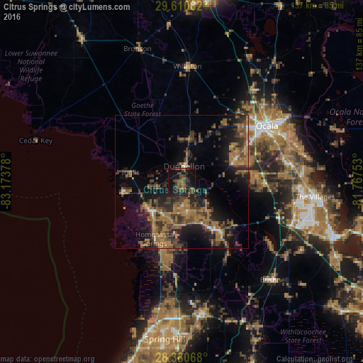
Analysis of Citrus Springs night lights 2016
Square area 10x10 km:
 0%
0%90-99
0%80-89
0%70-79
0%60-69
7.14%50-59
9.33%40-49
13.1%30-39
8.33%20-29
7.14%10-19
38.69%0-9
16.27%Square area 50x50 km:
0.35%90-99
0.63%80-89
0.5%70-79
0.98%60-69
8.14%50-59
3.78%40-49
4.97%30-39
5.06%20-29
5.92%10-19
12.1%0-9
57.56%Clear (daylight) street map image can be seen on geolist.org.
Map coordinates:
29° 36' 38.2" North, 83° 10' 25.6" West
28° 59' 50.9" North, 82° 28' 14.3" West
28° 22' 50.4" North, 81° 46' 3.1" West
Some cities around Citrus Springs sort by population:
• Homosassa Springs
23.9 km =14.9 mi,  205°
205°
• Pine Ridge
6.6 km =4.1 mi,  182°
182°
• Hernando
14.3 km =8.9 mi,  139°
139°
• Beverly Hills
9 km =5.6 mi,  172°
172°
• Sugarmill Woods
29.7 km =18.5 mi,  186°
186°
• Inverness
22.6 km =14 mi, 142°
• Inverness Highlands South
25.5 km =15.8 mi,  149°
149°
• Lecanto
16.3 km =10.1 mi, 185°
4151163 (p: 8,622)
Sources (retrieved 2019-11-25):
» Earth at Night: Flat Maps 2012, 2016