Hernando night lights from space
Night Light of Hernando (Florida) from space (United States) Src. Average luminocity for 10x10km area is 38.2619% and for 50x50km: 20.0632%.
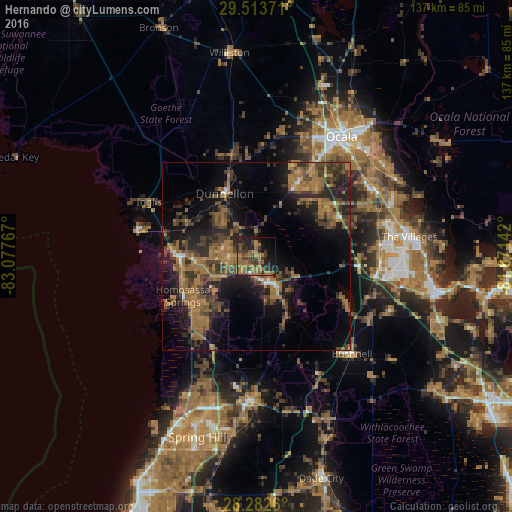
Analysis of Hernando night lights 2016
Square area 10x10 km:
 0.6%
0.6%90-99
0.2%80-89
0%70-79
1.19%60-69
25.2%50-59
10.12%40-49
9.52%30-39
12.5%20-29
11.51%10-19
18.85%0-9
10.32%Square area 50x50 km:
0.35%90-99
0.59%80-89
0.53%70-79
1.17%60-69
9.4%50-59
4.61%40-49
5.42%30-39
5.53%20-29
7.12%10-19
13.85%0-9
51.44%Clear (daylight) street map image can be seen on geolist.org.
Map coordinates:
29° 30' 49.4" North, 83° 4' 39.6" West
28° 53' 59.9" North, 82° 22' 28.3" West
28° 16' 57.4" North, 81° 40' 17.1" West
Some cities around Hernando sort by population:
• Pine Ridge
10.5 km =6.5 mi,  293°
293°
• Citrus Springs
14.3 km =8.9 mi,  319°
319°
• Beverly Hills
8.4 km =5.2 mi,  283°
283°
• Citrus Hills
5.8 km =3.6 mi,  257°
257°
• Inverness
8.3 km =5.2 mi,  148°
148°
• Inverness Highlands South
11.6 km =7.2 mi,  161°
161°
• Lecanto
12.2 km =7.6 mi,  243°
243°
• Floral City
18.3 km =11.4 mi, 155°
4158445 (p: 9,054)
Sources (retrieved 2019-11-25):
» Earth at Night: Flat Maps 2012, 2016