Centerville night lights from space
Night Light of Centerville (South Carolina) from space (United States) Src. Average luminocity for 10x10km area is 82.3443% and for 50x50km: 33.6964%.
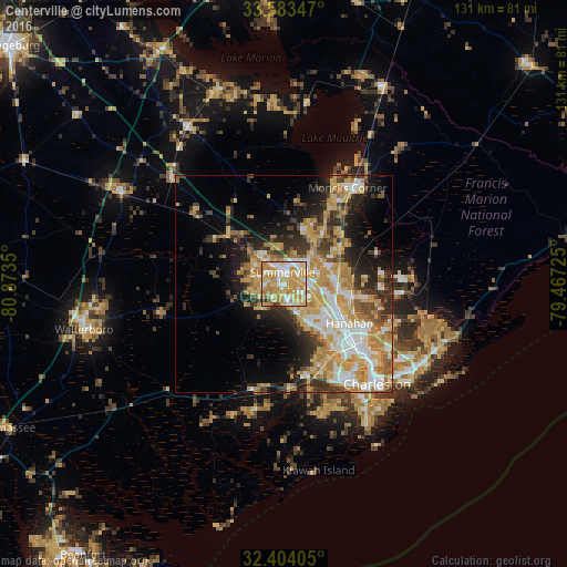
Analysis of Centerville night lights 2016
Square area 10x10 km:
 15.75%
90-99
19.23%80-89
19.23%70-79
32.78%60-69
9.34%50-59
1.1%40-49
0.37%30-39
2.01%20-29
0.18%10-19
0%0-9
0%Square area 50x50 km:
5.5%90-99
5.54%80-89
5.99%70-79
8.43%60-69
5.43%50-59
2.23%40-49
3.07%30-39
4.99%20-29
6.34%10-19
9.21%0-9
43.28%Clear (daylight) street map image can be seen on geolist.org.
Map coordinates:
33° 35' 0.5" North, 80° 52' 24.6" West
32° 59' 44.6" North, 80° 10' 13.3" West
32° 24' 14.6" North, 79° 28' 2.1" West
Some cities around Centerville sort by population:
• Charleston
33.1 km =20.6 mi,  137°
137°
• North Charleston
24.1 km =15 mi,  130°
130°
• Summerville
2.6 km =1.6 mi,  348°
348°
• Goose Creek
13 km =8.1 mi,  97°
97°
• Hanahan
16.3 km =10.1 mi,  121°
121°
• Ladson
5.8 km =3.6 mi, 101°
• Moncks Corner
26.6 km =16.5 mi,  33°
33°
• Sangaree
5.9 km =3.7 mi,  41°
41°
4574143 (p: 5,288)
Sources (retrieved 2019-11-25):
» Earth at Night: Flat Maps 2012, 2016