Brigham City night lights from space
Night Light of Brigham City (Utah) from space (United States) Src. Average luminocity for 10x10km area is 26.9915% and for 50x50km: 5.346%.
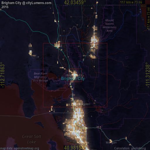
Analysis of Brigham City night lights 2016
Square area 10x10 km:
 2.89%
2.89%90-99
3.74%80-89
2.21%70-79
2.89%60-69
5.61%50-59
7.65%40-49
2.04%30-39
3.06%20-29
5.95%10-19
27.55%0-9
36.39%Square area 50x50 km:
0.22%90-99
0.37%80-89
0.4%70-79
0.69%60-69
0.96%50-59
1.53%40-49
1.47%30-39
0.94%20-29
1.29%10-19
3.95%0-9
88.18%Clear (daylight) street map image can be seen on geolist.org.
Map coordinates:
42° 2' 4.5" North, 112° 43' 7.1" West
41° 30' 36.8" North, 112° 0' 55.8" West
40° 58' 53.5" North, 111° 18' 44.6" West
Some cities around Brigham City sort by population:
• North Ogden
23 km =14.3 mi,  168°
168°
• Pleasant View
21.4 km =13.3 mi, 174°
• Tremonton
25.7 km =16 mi,  330°
330°
• Hyrum
19.3 km =12 mi,  44°
44°
• Farr West
23.7 km =14.7 mi,  182°
182°
• Nibley
23.7 km =14.7 mi, 39°
• Plain City
24.3 km =15.1 mi,  194°
194°
• Harrisville
25.6 km =15.9 mi, 174°
5771960 (p: 18,752)
Sources (retrieved 2019-11-25):
» Earth at Night: Flat Maps 2012, 2016