Harrisville night lights from space
Night Light of Harrisville (Utah) from space (United States) Src. Average luminocity for 10x10km area is 61.0763% and for 50x50km: 13.3906%.
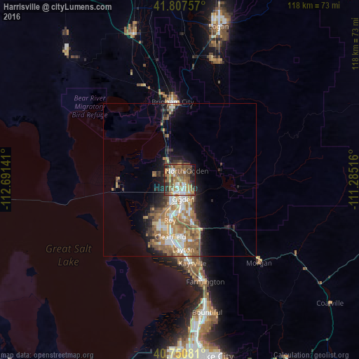
Analysis of Harrisville night lights 2016
Square area 10x10 km:
 9.74%
9.74%90-99
8.44%80-89
4.38%70-79
12.34%60-69
15.1%50-59
18.02%40-49
13.15%30-39
6.98%20-29
7.79%10-19
3.9%0-9
0.16%Square area 50x50 km:
1.86%90-99
2.08%80-89
1.26%70-79
2.3%60-69
2.87%50-59
3.21%40-49
1.85%30-39
1.52%20-29
2.58%10-19
4.98%0-9
75.5%Clear (daylight) street map image can be seen on geolist.org.
Map coordinates:
41° 48' 27.3" North, 112° 41' 29.1" West
41° 16' 52.8" North, 111° 59' 17.8" West
40° 45' 2.9" North, 111° 17' 6.6" West
Some cities around Harrisville sort by population:
• Ogden
6.6 km =4.1 mi,  169°
169°
• North Ogden
3.7 km =2.3 mi,  39°
39°
• South Ogden
10 km =6.2 mi, 171°
• West Haven
10.2 km =6.3 mi,  211°
211°
• Pleasant View
4.1 km =2.5 mi,  355°
355°
• Riverdale
11.7 km =7.3 mi,  186°
186°
• Farr West
3.7 km =2.3 mi,  298°
298°
• Plain City
8.4 km =5.2 mi,  282°
282°
5775615 (p: 6,221)
Sources (retrieved 2019-11-25):
» Earth at Night: Flat Maps 2012, 2016