North Ogden night lights from space
Night Light of North Ogden (Utah) from space (United States) Src. Average luminocity for 10x10km area is 36.7029% and for 50x50km: 12.7267%.
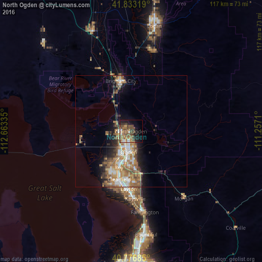
Analysis of North Ogden night lights 2016
Square area 10x10 km:
 3.25%
3.25%90-99
3.25%80-89
1.62%70-79
6.49%60-69
7.79%50-59
12.82%40-49
12.18%30-39
4.38%20-29
5.84%10-19
19.81%0-9
22.56%Square area 50x50 km:
1.82%90-99
2.01%80-89
1.22%70-79
2.27%60-69
2.65%50-59
2.82%40-49
1.72%30-39
1.47%20-29
2.44%10-19
4.76%0-9
76.83%Clear (daylight) street map image can be seen on geolist.org.
Map coordinates:
41° 49' 59.5" North, 112° 39' 48.1" West
41° 18' 25.8" North, 111° 57' 36.8" West
40° 46' 36.7" North, 111° 15' 25.6" West
Some cities around North Ogden sort by population:
• Ogden
9.4 km =5.8 mi,  186°
186°
• South Ogden
12.9 km =8 mi,  184°
184°
• West Haven
13.8 km =8.6 mi,  213°
213°
• Pleasant View
2.9 km =1.8 mi,  294°
294°
• Riverdale
14.9 km =9.3 mi, 194°
• Farr West
5.7 km =3.5 mi,  258°
258°
• Plain City
10.6 km =6.6 mi, 264°
• Harrisville
3.7 km =2.3 mi,  219°
219°
5779036 (p: 18,446)
Sources (retrieved 2019-11-25):
» Earth at Night: Flat Maps 2012, 2016