Boulder City night lights from space
Night Light of Boulder City (Nevada) from space (United States) Src. Average luminocity for 10x10km area is 27.2234% and for 50x50km: 15.6276%.
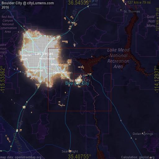
Analysis of Boulder City night lights 2016
Square area 10x10 km:
 1.65%
1.65%90-99
4.21%80-89
0.92%70-79
3.85%60-69
8.06%50-59
6.04%40-49
1.47%30-39
3.48%20-29
2.75%10-19
41.03%0-9
26.56%Square area 50x50 km:
5.15%90-99
3.12%80-89
1.05%70-79
1.1%60-69
2.94%50-59
1.9%40-49
1.53%30-39
1.49%20-29
1.81%10-19
5.2%0-9
74.72%Clear (daylight) street map image can be seen on geolist.org.
Map coordinates:
36° 32' 43.9" North, 115° 32' 8.2" West
35° 58' 42.9" North, 114° 49' 57" West
35° 24' 27.2" North, 114° 7' 45.7" West
Some cities around Boulder City sort by population:
• Las Vegas
35 km =21.7 mi,  308°
308°
• Henderson
15.1 km =9.4 mi,  296°
296°
• North Las Vegas
35.4 km =22 mi, 313°
• Paradise
31.2 km =19.4 mi, 295°
• Sunrise Manor
33.7 km =20.9 mi,  320°
320°
• Enterprise
37.2 km =23.1 mi,  278°
278°
• Whitney
22.6 km =14 mi, 305°
• Winchester
30.8 km =19.1 mi, 303°
5500539 (p: 15,551)
Sources (retrieved 2019-11-25):
» Earth at Night: Flat Maps 2012, 2016