Zuhres night lights from space
Night Light of Zuhres (Donetsk) from space (Ukraine) Src. Average luminocity for 10x10km area is 1.848% and for 50x50km: 3.5589%.
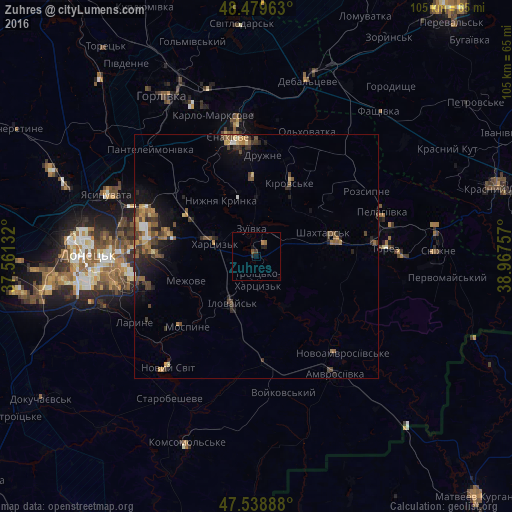
Analysis of Zuhres night lights 2016
Square area 10x10 km:
 0%
0%90-99
0%80-89
0%70-79
0.57%60-69
0.57%50-59
0.43%40-49
0.14%30-39
0.57%20-29
1.28%10-19
0.99%0-9
95.45%Square area 50x50 km:
0.14%90-99
0.27%80-89
0.34%70-79
0.59%60-69
0.61%50-59
0.8%40-49
0.93%30-39
0.76%20-29
1.05%10-19
2.17%0-9
92.34%Clear (daylight) street map image can be seen on geolist.org.
Map coordinates:
48° 28' 46.7" North, 37° 33' 40.8" East
48° 0' 41" North, 38° 15' 52" East
47° 32' 20" North, 38° 58' 3.3" East
Some cities around Zuhres sort by population:
• Makiyivka
25.5 km =15.8 mi,  279°
279°
• Yenakiyeve
25 km =15.5 mi,  350°
350°
• Shakhtars’k
13.9 km =8.6 mi,  68°
68°
• Chystyakove
24.9 km =15.5 mi,  82°
82°
• Khartsyz’k
9.4 km =5.8 mi,  291°
291°
• Ilovays’k
10.7 km =6.6 mi,  205°
205°
• Nyzhnya Krynka
13.7 km =8.5 mi,  325°
325°
• Mospyne
20.1 km =12.5 mi,  228°
228°
686818 (p: 19,121)
Sources (retrieved 2019-11-25):
» Earth at Night: Flat Maps 2012, 2016