Sofiyivka night lights from space
Night Light of Sofiyivka (Dnipropetrovsk) from space (Ukraine) Src. Average luminocity for 10x10km area is 0.2429% and for 50x50km: 0.662%.
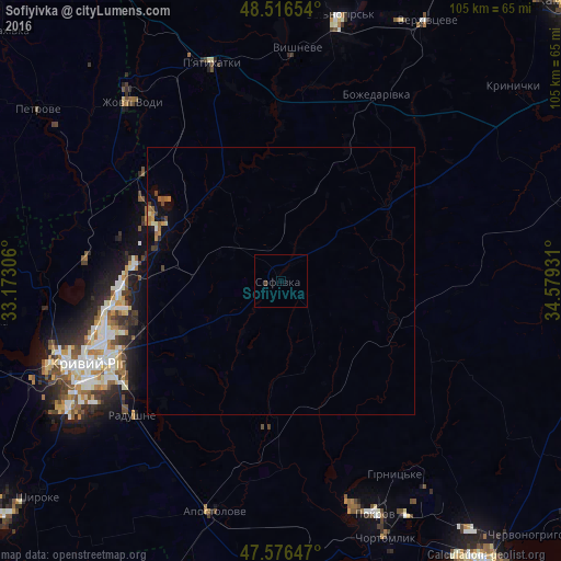
Analysis of Sofiyivka night lights 2016
Square area 10x10 km:
 0%
0%90-99
0%80-89
0%70-79
0%60-69
0%50-59
0%40-49
0.43%30-39
0.14%20-29
0%10-19
0%0-9
99.43%Square area 50x50 km:
0%90-99
0.06%80-89
0.06%70-79
0.13%60-69
0.14%50-59
0.14%40-49
0.12%30-39
0.11%20-29
0.09%10-19
0.43%0-9
98.74%Clear (daylight) street map image can be seen on geolist.org.
Map coordinates:
48° 30' 59.5" North, 33° 10' 23" East
48° 2' 55.1" North, 33° 52' 34.2" East
47° 34' 35.3" North, 34° 34' 45.5" East
Some cities around Sofiyivka sort by population:
• Kryvyi Rih
40 km =24.9 mi,  247°
247°
• Zhovti Vody
43 km =26.7 mi,  320°
320°
• Piatykhatky
42.4 km =26.3 mi,  343°
343°
• Apostolove
44.9 km =27.9 mi,  195°
195°
• Shyroke
60.9 km =37.8 mi,  229°
229°
• Petrove
55.3 km =34.4 mi,  303°
303°
• Novovorontsovka
61 km =37.9 mi,  177°
177°
• Lozuvatka
43.9 km =27.3 mi,  271°
271°
693325 (p: 8,017)
Sources (retrieved 2019-11-25):
» Earth at Night: Flat Maps 2012, 2016