Rudne night lights from space
Night Light of Rudne (Lviv) from space (Ukraine) Src. Average luminocity for 10x10km area is 30.6912% and for 50x50km: 7.2188%.
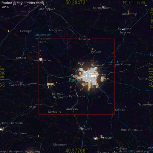
Analysis of Rudne night lights 2016
Square area 10x10 km:
 5.88%
5.88%90-99
6.68%80-89
2.67%70-79
2.81%60-69
2.54%50-59
4.81%40-49
3.21%30-39
9.36%20-29
10.29%10-19
12.7%0-9
39.04%Square area 50x50 km:
2.07%90-99
1.6%80-89
0.55%70-79
0.55%60-69
0.47%50-59
0.69%40-49
0.57%30-39
1.22%20-29
2.09%10-19
3.52%0-9
86.67%Clear (daylight) street map image can be seen on geolist.org.
Map coordinates:
50° 17' 5" North, 23° 11' 48.8" East
49° 49' 60" North, 23° 54' 0" East
49° 22' 39.6" North, 24° 36' 11.3" East
Some cities around Rudne sort by population:
• Lviv
8.9 km =5.5 mi,  86°
86°
• Horodok
18.9 km =11.7 mi,  253°
253°
• Zhovkva
25.5 km =15.8 mi,  11°
11°
• Pustomyty
13.2 km =8.2 mi,  175°
175°
• Dublyany
15.5 km =9.6 mi,  59°
59°
• Ivano-Frankove
15.6 km =9.7 mi,  308°
308°
• Shchyrets
20.4 km =12.7 mi,  185°
185°
• Bryukhovychi
9 km =5.6 mi,  28°
28°
695205 (p: 6,016)
Sources (retrieved 2019-11-25):
» Earth at Night: Flat Maps 2012, 2016