Yenifakılı night lights from space
Night Light of Yenifakılı (Yozgat) from space (Turkey) Src. Average luminocity for 10x10km area is 4.1888% and for 50x50km: 3.7455%.
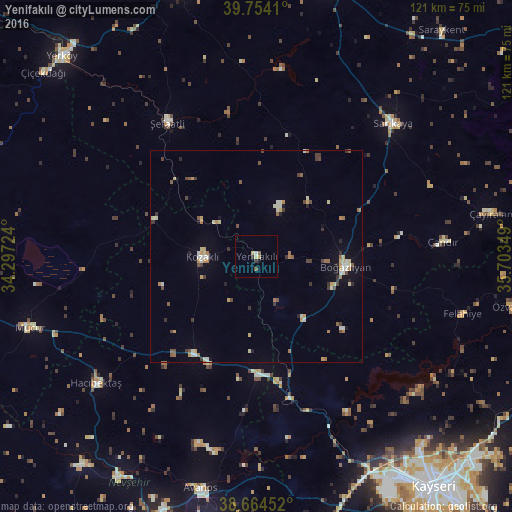
Analysis of Yenifakılı night lights 2016
Square area 10x10 km:
 0%
0%90-99
0.68%80-89
1.19%70-79
0.51%60-69
0.34%50-59
1.02%40-49
0.34%30-39
0.68%20-29
0.68%10-19
0.68%0-9
93.88%Square area 50x50 km:
0.07%90-99
0.77%80-89
0.62%70-79
0.46%60-69
0.53%50-59
0.47%40-49
0.52%30-39
0.66%20-29
0.45%10-19
0.89%0-9
94.55%Clear (daylight) street map image can be seen on geolist.org.
Map coordinates:
39° 45' 14.8" North, 34° 17' 50.1" East
39° 12' 41.1" North, 35° 0' 1.3" East
38° 39' 52.3" North, 35° 42' 12.6" East
Some cities around Yenifakılı sort by population:
• Mucur
55.8 km =34.7 mi,  252°
252°
• Çayıralan
56.3 km =35 mi,  79°
79°
• Şefaatlı
38.7 km =24 mi,  327°
327°
• Avanos
56.8 km =35.3 mi,  193°
193°
• Gülşehir
61.1 km =38 mi,  212°
212°
• Hacıbektaş
48.6 km =30.2 mi,  231°
231°
• Göreme
64.7 km =40.2 mi, 192°
• Felahiye
50.7 km =31.5 mi,  105°
105°
297099 (p: 11,470)
Sources (retrieved 2019-11-25):
» Earth at Night: Flat Maps 2012, 2016