Sultanhisar night lights from space
Night Light of Sultanhisar (Aydın) from space (Turkey) Src. Average luminocity for 10x10km area is 22.9221% and for 50x50km: 11.9053%.
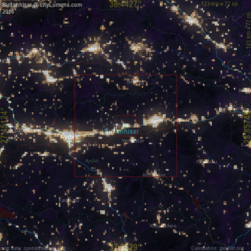
Analysis of Sultanhisar night lights 2016
Square area 10x10 km:
 0.32%
0.32%90-99
5.03%80-89
3.57%70-79
1.46%60-69
2.6%50-59
1.46%40-49
2.11%30-39
6.49%20-29
4.22%10-19
42.05%0-9
30.68%Square area 50x50 km:
0.65%90-99
1.84%80-89
1.14%70-79
1.58%60-69
1.4%50-59
1.16%40-49
2.08%30-39
2.6%20-29
3.14%10-19
12.29%0-9
72.13%Clear (daylight) street map image can be seen on geolist.org.
Map coordinates:
38° 26' 33.7" North, 27° 27' 4.5" East
37° 53' 23.6" North, 28° 9' 15.7" East
37° 19' 58.4" North, 28° 51' 27" East
Some cities around Sultanhisar sort by population:
• Aydın
28.1 km =17.5 mi,  259°
259°
• Nazilli
15 km =9.3 mi,  78°
78°
• Çine
31.9 km =19.8 mi,  195°
195°
• Köşk
9.9 km =6.2 mi,  245°
245°
• Bozdoğan
28.1 km =17.5 mi,  150°
150°
• Atça
5.3 km =3.3 mi,  91°
91°
• Kuyucak
26.9 km =16.7 mi, 84°
• Yenipazar
8.2 km =5.1 mi, 153°
300195 (p: 6,259)
Sources (retrieved 2019-11-25):
» Earth at Night: Flat Maps 2012, 2016