Nurdağı night lights from space
Night Light of Nurdağı (Gaziantep) from space (Turkey) Src. Average luminocity for 10x10km area is 28.5476% and for 50x50km: 8.2347%.
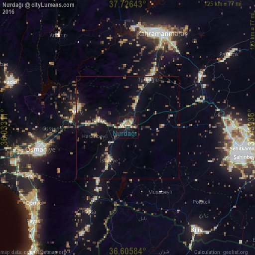
Analysis of Nurdağı night lights 2016
Square area 10x10 km:
 0%
0%90-99
7.31%80-89
4.42%70-79
5.95%60-69
4.25%50-59
2.55%40-49
3.57%30-39
1.87%20-29
2.04%10-19
33.84%0-9
34.18%Square area 50x50 km:
0.16%90-99
1.17%80-89
1.07%70-79
1.02%60-69
0.73%50-59
1.02%40-49
1.76%30-39
1.62%20-29
1.18%10-19
9.47%0-9
80.8%Clear (daylight) street map image can be seen on geolist.org.
Map coordinates:
37° 43' 35.1" North, 36° 1' 59.2" East
37° 10' 5.6" North, 36° 44' 10.4" East
36° 36' 21" North, 37° 26' 21.7" East
Some cities around Nurdağı sort by population:
• Kahramanmaraş
49.3 km =30.6 mi,  19°
19°
• Osmaniye
44.5 km =27.7 mi,  256°
256°
• Erzin
53.4 km =33.2 mi,  243°
243°
• Bahçe
14.5 km =9 mi,  282°
282°
• Hassa
45.4 km =28.2 mi,  205°
205°
• Toprakkale
53.4 km =33.2 mi, 258°
• Hasanbeyli
17.4 km =10.8 mi, 255°
• Mahmutlar
54.1 km =33.6 mi, 243°
415534 (p: 12,827)
Sources (retrieved 2019-11-25):
» Earth at Night: Flat Maps 2012, 2016