Bahçe night lights from space
Night Light of Bahçe (Adana) from space (Turkey) Src. Average luminocity for 10x10km area is 26.3401% and for 50x50km: 10.3716%.
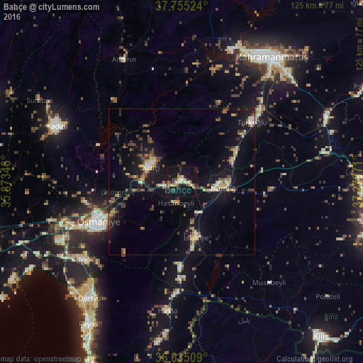
Analysis of Bahçe night lights 2016
Square area 10x10 km:
 0.51%
0.51%90-99
4.59%80-89
2.89%70-79
5.27%60-69
4.42%50-59
1.19%40-49
2.72%30-39
5.44%20-29
3.74%10-19
47.28%0-9
21.94%Square area 50x50 km:
0.21%90-99
1.24%80-89
1.25%70-79
1.42%60-69
1.07%50-59
1.42%40-49
1.95%30-39
2.43%20-29
1.99%10-19
12.31%0-9
74.71%Clear (daylight) street map image can be seen on geolist.org.
Map coordinates:
37° 45' 18.9" North, 35° 52' 24.5" East
37° 11' 50.1" North, 36° 34' 35.7" East
36° 38' 6.3" North, 37° 16' 47" East
Some cities around Bahçe sort by population:
• Osmaniye
32.2 km =20 mi,  244°
244°
• Erzin
43.1 km =26.8 mi,  231°
231°
• Nurdağı
14.5 km =9 mi,  102°
102°
• Hassa
44.5 km =27.7 mi,  186°
186°
• Andırın
46.6 km =29 mi,  335°
335°
• Toprakkale
40.7 km =25.3 mi,  249°
249°
• Hasanbeyli
8.1 km =5 mi,  199°
199°
• Mahmutlar
43.9 km =27.3 mi, 231°
322391 (p: 19,566)
Sources (retrieved 2019-11-25):
» Earth at Night: Flat Maps 2012, 2016