Mahmutlar night lights from space
Night Light of Mahmutlar (Hatay) from space (Turkey) Src. Average luminocity for 10x10km area is 36.8718% and for 50x50km: 17.9896%.
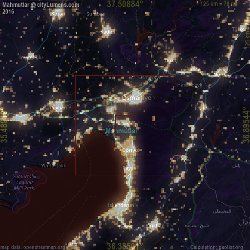
Analysis of Mahmutlar night lights 2016
Square area 10x10 km:
 1.62%
1.62%90-99
7.63%80-89
4.22%70-79
5.68%60-69
1.79%50-59
4.38%40-49
6.17%30-39
5.19%20-29
31.66%10-19
31.66%0-9
0%Square area 50x50 km:
1.25%90-99
2.82%80-89
2.62%70-79
3.19%60-69
1.36%50-59
2.04%40-49
3.3%30-39
3.42%20-29
7.45%10-19
13.77%0-9
58.8%Clear (daylight) street map image can be seen on geolist.org.
Map coordinates:
37° 30' 31.8" North, 35° 29' 21.1" East
36° 56' 56.4" North, 36° 11' 32.3" East
36° 23' 6" North, 36° 53' 43.6" East
Some cities around Mahmutlar sort by population:
• Osmaniye
14.8 km =9.2 mi,  19°
19°
• Ceyhan
34.3 km =21.3 mi,  284°
284°
• Dörtyol
12.7 km =7.9 mi,  164°
164°
• Erzin
0.7 km =0.4 mi,  47°
47°
• Denizciler
34.3 km =21.3 mi,  176°
176°
• Hassa
33.4 km =20.8 mi,  119°
119°
• Toprakkale
13.9 km =8.6 mi,  343°
343°
• Hasanbeyli
37.2 km =23.1 mi,  57°
57°
436507 (p: 5,800)
Sources (retrieved 2019-11-25):
» Earth at Night: Flat Maps 2012, 2016