Çiftlikköy night lights from space
Night Light of Çiftlikköy (Yalova) from space (Turkey) Src. Average luminocity for 10x10km area is 41.1088% and for 50x50km: 24.4482%.
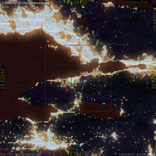
Analysis of Çiftlikköy night lights 2016
Square area 10x10 km:
 4.71%
4.71%90-99
6.82%80-89
5.36%70-79
3.25%60-69
9.58%50-59
9.09%40-49
4.06%30-39
2.44%20-29
11.85%10-19
40.1%0-9
2.76%Square area 50x50 km:
4.34%90-99
4.48%80-89
2.78%70-79
2.37%60-69
3.65%50-59
4.02%40-49
2.51%30-39
2.97%20-29
7.73%10-19
15.83%0-9
49.31%Clear (daylight) street map image can be seen on geolist.org.
Map coordinates:
41° 11' 29.5" North, 28° 37' 13.8" East
40° 39' 37" North, 29° 19' 25" East
40° 7' 29.2" North, 30° 1' 36.3" East
Some cities around Çiftlikköy sort by population:
• Maltepe
33.7 km =20.9 mi,  335°
335°
• Gebze
18.2 km =11.3 mi,  29°
29°
• Yalova
4 km =2.5 mi,  261°
261°
• Gemlik
29 km =18 mi,  208°
208°
• Orhangazi
19.1 km =11.9 mi,  183°
183°
• Karamürsel
24.9 km =15.5 mi,  82°
82°
• Çınarcık
16.9 km =10.5 mi, 264°
• Adalar
28.1 km =17.5 mi,  325°
325°
749163 (p: 5,750)
Sources (retrieved 2019-11-25):
» Earth at Night: Flat Maps 2012, 2016