Çınarcık night lights from space
Night Light of Çınarcık (Yalova) from space (Turkey) Src. Average luminocity for 10x10km area is 22.3945% and for 50x50km: 15.097%.
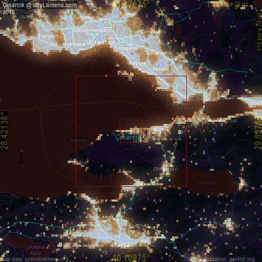
Analysis of Çınarcık night lights 2016
Square area 10x10 km:
 0%
0%90-99
2.44%80-89
3.73%70-79
3.9%60-69
4.06%50-59
5.52%40-49
0.81%30-39
5.36%20-29
2.76%10-19
23.05%0-9
48.38%Square area 50x50 km:
2.6%90-99
2.58%80-89
1.75%70-79
1.45%60-69
2.05%50-59
2.32%40-49
1.51%30-39
1.59%20-29
4.06%10-19
12.53%0-9
67.55%Clear (daylight) street map image can be seen on geolist.org.
Map coordinates:
41° 10' 36.3" North, 28° 25' 17" East
40° 38' 43.4" North, 29° 7' 28.2" East
40° 6' 35.1" North, 29° 49' 39.5" East
Some cities around Çınarcık sort by population:
• Maltepe
32.4 km =20.1 mi,  4°
4°
• Gebze
31.2 km =19.4 mi,  55°
55°
• Yalova
12.9 km =8 mi,  85°
85°
• Gemlik
24 km =14.9 mi,  172°
172°
• Orhangazi
23.3 km =14.5 mi,  138°
138°
• Mudanya
36.4 km =22.6 mi,  214°
214°
• Adalar
24.7 km =15.3 mi, 1°
• Çiftlikköy
16.9 km =10.5 mi,  84°
84°
749075 (p: 7,629)
Sources (retrieved 2019-11-25):
» Earth at Night: Flat Maps 2012, 2016