Bayındır night lights from space
Night Light of Bayındır (İzmir) from space (Turkey) Src. Average luminocity for 10x10km area is 32.8095% and for 50x50km: 13.6862%.
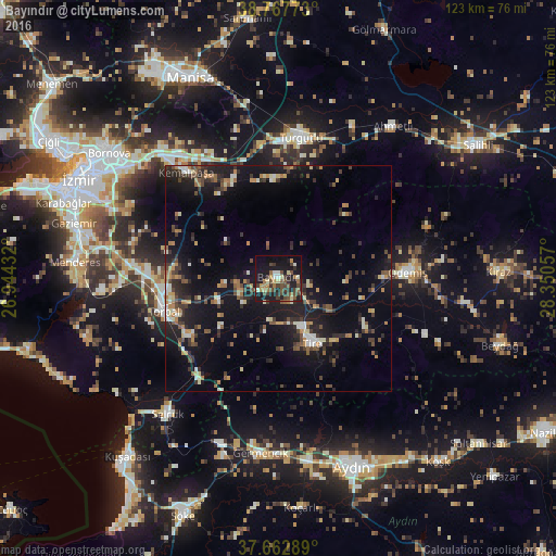
Analysis of Bayındır night lights 2016
Square area 10x10 km:
 2.04%
2.04%90-99
2.89%80-89
4.25%70-79
2.21%60-69
6.29%50-59
5.44%40-49
11.73%30-39
8.67%20-29
4.25%10-19
39.12%0-9
13.1%Square area 50x50 km:
0.54%90-99
1.86%80-89
1.31%70-79
1.46%60-69
1.98%50-59
1.77%40-49
2.49%30-39
3.04%20-29
3.93%10-19
14.56%0-9
67.07%Clear (daylight) street map image can be seen on geolist.org.
Map coordinates:
38° 46' 3.8" North, 26° 56' 39.6" East
38° 13' 2.7" North, 27° 38' 50.8" East
37° 39' 46.4" North, 28° 21' 2.1" East
Some cities around Bayındır sort by population:
• Turgutlu
31.2 km =19.4 mi,  8°
8°
• Ödemiş
28.2 km =17.5 mi,  87°
87°
• Torbalı
26 km =16.2 mi,  253°
253°
• Tire
16.2 km =10.1 mi,  151°
151°
• Kemalpaşa
30.7 km =19.1 mi,  319°
319°
• Selçuk
38.4 km =23.9 mi,  219°
219°
• İncirliova
41.1 km =25.5 mi,  170°
170°
• Germencik
38.8 km =24.1 mi,  185°
185°
321786 (p: 16,850)
Sources (retrieved 2019-11-25):
» Earth at Night: Flat Maps 2012, 2016