Altınyayla night lights from space
Night Light of Altınyayla (Sivas) from space (Turkey) Src. Average luminocity for 10x10km area is 4.1548% and for 50x50km: 1.0635%.
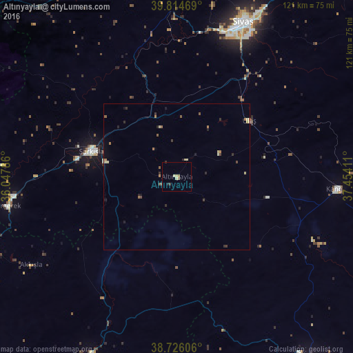
Analysis of Altınyayla night lights 2016
Square area 10x10 km:
 0%
0%90-99
0.68%80-89
1.36%70-79
0%60-69
1.36%50-59
0%40-49
0.34%30-39
1.02%20-29
0.68%10-19
0%0-9
94.56%Square area 50x50 km:
0%90-99
0.09%80-89
0.29%70-79
0.05%60-69
0.28%50-59
0.15%40-49
0.15%30-39
0.29%20-29
0.26%10-19
0.15%0-9
98.27%Clear (daylight) street map image can be seen on geolist.org.
Map coordinates:
39° 48' 52.9" North, 36° 2' 52.3" East
39° 16' 21" North, 36° 45' 3.5" East
38° 43' 33.8" North, 37° 27' 14.8" East
Some cities around Altınyayla sort by population:
• Sivas
57.6 km =35.8 mi,  23°
23°
• Şarkışla
30.7 km =19.1 mi,  286°
286°
• Akdağmadeni
86 km =53.4 mi,  300°
300°
• Gemerek
59.3 km =36.8 mi,  260°
260°
• Gürün
75.9 km =47.2 mi,  143°
143°
• Pınarbaşı
68.5 km =42.6 mi,  206°
206°
• Kangal
55.3 km =34.4 mi,  94°
94°
• Sarıoğlan
71 km =44.1 mi,  252°
252°
323886 (p: 5,674)
Sources (retrieved 2019-11-25):
» Earth at Night: Flat Maps 2012, 2016