Bang Pa-in night lights from space
Night Light of Bang Pa-in (Phra Nakhon Si Ayutthaya) from space (Thailand) Src. Average luminocity for 10x10km area is 70.4545% and for 50x50km: 50.5698%.
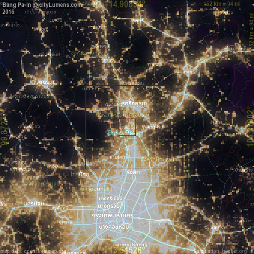
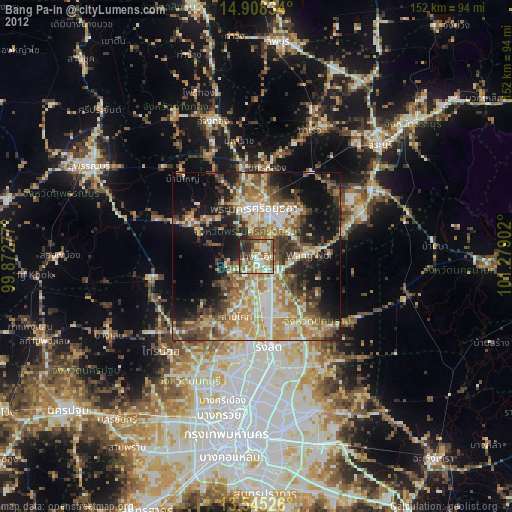
Analysis of Bang Pa-in night lights 2016
Square area 10x10 km:
 9.31%
9.31%90-99
10.82%80-89
15.37%70-79
17.32%60-69
18.61%50-59
6.93%40-49
14.07%30-39
7.58%20-29
0%10-19
0%0-9
0%Square area 50x50 km:
4.96%90-99
5.97%80-89
11.32%70-79
10.65%60-69
10.52%50-59
7.51%40-49
8.64%30-39
9.15%20-29
10.46%10-19
10.6%0-9
10.21%Clear (daylight) street map image can be seen on geolist.org.
Map coordinates:
14° 54' 30" North, 99° 52' 22" East
14° 13' 40.2" North, 100° 34' 33.2" East
13° 32' 42.9" North, 101° 16' 44.5" East
Some cities around Bang Pa-in sort by population:
• Khlong Luang
19.6 km =12.2 mi,  157°
157°
• Phra Nakhon Si Ayutthaya
13.8 km =8.6 mi,  0°
0°
• Nong Khae
33.8 km =21 mi,  68°
68°
• Ban Bang Kadi Pathum Thani
25.6 km =15.9 mi,  186°
186°
• Pathum Thani
24.3 km =15.1 mi, 191°
• Phak Hai
33.8 km =21 mi,  318°
318°
• Wang Noi
15 km =9.3 mi,  90°
90°
• Nakhon Luang
26.4 km =16.4 mi,  7°
7°
1619369 (p: 20,484)
Sources (retrieved 2019-11-25):
» Earth at Night: Flat Maps 2012, 2016