Ban Mo night lights from space
Night Light of Ban Mo (Saraburi) from space (Thailand) Src. Average luminocity for 10x10km area is 36.6515% and for 50x50km: 30.7168%.
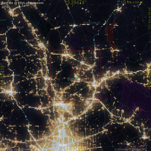
Analysis of Ban Mo night lights 2016
Square area 10x10 km:
 0.87%
0.87%90-99
1.73%80-89
5.63%70-79
5.84%60-69
7.36%50-59
8.23%40-49
8.44%30-39
14.94%20-29
10.39%10-19
26.19%0-9
10.39%Square area 50x50 km:
1.28%90-99
1.79%80-89
4.88%70-79
3.96%60-69
6.3%50-59
5.61%40-49
7.34%30-39
7.78%20-29
13.08%10-19
23.75%0-9
24.22%Clear (daylight) street map image can be seen on geolist.org.
Map coordinates:
15° 17' 41.1" North, 100° 1' 27.1" East
14° 36' 55.6" North, 100° 43' 38.3" East
13° 56' 2.5" North, 101° 25' 49.6" East
Some cities around Ban Mo sort by population:
• Saraburi
22.3 km =13.9 mi,  114°
114°
• Lop Buri
21.8 km =13.5 mi,  338°
338°
• Phra Phutthabat
14.2 km =8.8 mi,  30°
30°
• Kaeng Khoi
29.3 km =18.2 mi,  96°
96°
• Tha Ruea
5.3 km =3.3 mi,  181°
181°
• Nakhon Luang
21.3 km =13.2 mi,  217°
217°
• Ban Thai Tan
25.8 km =16 mi,  271°
271°
• Chaiyo
28.6 km =17.8 mi,  283°
283°
1616658 (p: 15,959)
Sources (retrieved 2019-11-25):
» Earth at Night: Flat Maps 2012, 2016