Gabčíkovo night lights from space
Night Light of Gabčíkovo (Trnavský kraj) from space (Slovakia) Src. Average luminocity for 10x10km area is 3.5% and for 50x50km: 5.4826%.
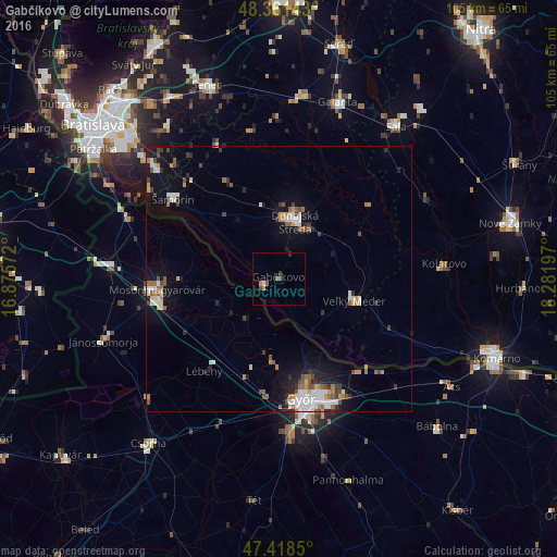
Analysis of Gabčíkovo night lights 2016
Square area 10x10 km:
 0.28%
0.28%90-99
0.28%80-89
0%70-79
0%60-69
1.7%50-59
0.57%40-49
1.14%30-39
0.57%20-29
0.57%10-19
0%0-9
94.89%Square area 50x50 km:
0.85%90-99
0.99%80-89
0.46%70-79
0.5%60-69
0.7%50-59
0.82%40-49
0.74%30-39
0.67%20-29
0.88%10-19
3.63%0-9
89.75%Clear (daylight) street map image can be seen on geolist.org.
Map coordinates:
48° 21' 41.1" North, 16° 52' 32.6" East
47° 53' 31.6" North, 17° 34' 43.8" East
47° 25' 6.6" North, 18° 16' 55.1" East
Some cities around Gabčíkovo sort by population:
• Győr, HU
23.6 km =14.7 mi,  169°
169°
• Mosonmagyaróvár, HU
23.2 km =14.4 mi,  263°
263°
• Dunajská Streda
11.5 km =7.1 mi,  12°
12°
• Galanta
34.9 km =21.7 mi,  18°
18°
• Šamorín
25.2 km =15.7 mi,  307°
307°
• Kolárovo
30.4 km =18.9 mi,  83°
83°
• Veľký Meder
14.7 km =9.1 mi,  104°
104°
• Sládkovičovo
34.7 km =21.6 mi, 7°
3060224 (p: 5,343)
Sources (retrieved 2019-11-25):
» Earth at Night: Flat Maps 2012, 2016