Vitomarci night lights from space
Night Light of Vitomarci (Sveti Andraž v Slovenskih Goricah) from space (Slovenia) Src. Average luminocity for 10x10km area is 0.7528% and for 50x50km: 6.7026%.
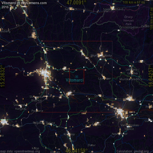
Analysis of Vitomarci night lights 2016
Square area 10x10 km:
 0%
0%90-99
0%80-89
0%70-79
0%60-69
0%50-59
0.57%40-49
0%30-39
0.28%20-29
0.57%10-19
0%0-9
98.58%Square area 50x50 km:
0.83%90-99
1.1%80-89
0.51%70-79
0.56%60-69
0.77%50-59
1.32%40-49
0.96%30-39
1.06%20-29
1.98%10-19
2.78%0-9
88.14%Clear (daylight) street map image can be seen on geolist.org.
Map coordinates:
47° 0' 32.8" North, 15° 14' 10.8" East
46° 31' 39" North, 15° 56' 22" East
46° 2' 29.7" North, 16° 38' 33.3" East
Some cities around Vitomarci sort by population:
• Lenart v Slov. Goricah
9.9 km =6.2 mi,  303°
303°
• Benedikt
9.8 km =6.1 mi,  336°
336°
• Sv. Trojica v Slov. Goricah
7.3 km =4.5 mi,  318°
318°
• Trnovska Vas
4.1 km =2.5 mi,  258°
258°
• Juršinci
5.3 km =3.3 mi,  152°
152°
• Sveti Jurij ob Ščavnici
7.9 km =4.9 mi,  53°
53°
• Destrnik
6 km =3.7 mi,  229°
229°
• Cerkvenjak
4.8 km =3 mi,  3°
3°
3187575 (p: 329)
Sources (retrieved 2019-11-25):
» Earth at Night: Flat Maps 2012, 2016