Destrnik night lights from space
Night Light of Destrnik from space (Slovenia) Src. Average luminocity for 10x10km area is 1.0355% and for 50x50km: 7.2058%.
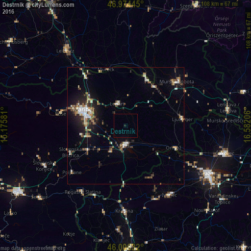
Analysis of Destrnik night lights 2016
Square area 10x10 km:
 0%
0%90-99
0%80-89
0%70-79
0%60-69
0%50-59
0%40-49
0%30-39
0.28%20-29
0.28%10-19
0%0-9
99.43%Square area 50x50 km:
0.86%90-99
1.24%80-89
0.48%70-79
0.5%60-69
0.88%50-59
1.28%40-49
1.24%30-39
1.2%20-29
2.14%10-19
3.53%0-9
86.66%Clear (daylight) street map image can be seen on geolist.org.
Map coordinates:
46° 58' 28" North, 15° 10' 32.9" East
46° 29' 33.1" North, 15° 52' 44.1" East
46° 0' 22.8" North, 16° 34' 55.4" East
Some cities around Destrnik sort by population:
• Ptuj
8.1 km =5 mi,  184°
184°
• Dornava
8.4 km =5.2 mi,  137°
137°
• Starše
9.1 km =5.7 mi,  250°
250°
• Sv. Trojica v Slov. Goricah
9.4 km =5.8 mi,  359°
359°
• Trnovska Vas
3.1 km =1.9 mi,  10°
10°
• Vitomarci
6 km =3.7 mi,  49°
49°
• Juršinci
7.1 km =4.4 mi,  97°
97°
• Spodnja Hajdina
9.6 km =6 mi,  194°
194°
3202058 (p: 172)
Sources (retrieved 2019-11-25):
» Earth at Night: Flat Maps 2012, 2016