Sveti Tomaž night lights from space
Night Light of Sveti Tomaž from space (Slovenia) Src. Average luminocity for 10x10km area is 0.0085% and for 50x50km: 5.2826%.
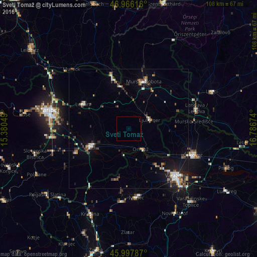
Analysis of Sveti Tomaž night lights 2016
Square area 10x10 km:
 0%
0%90-99
0%80-89
0%70-79
0%60-69
0%50-59
0%40-49
0%30-39
0%20-29
0%10-19
0%0-9
100%Square area 50x50 km:
0.71%90-99
0.81%80-89
0.37%70-79
0.38%60-69
0.52%50-59
1.13%40-49
0.8%30-39
0.97%20-29
1.19%10-19
2.8%0-9
90.33%Clear (daylight) street map image can be seen on geolist.org.
Map coordinates:
46° 57' 58.2" North, 15° 22' 49.8" East
46° 29' 3" North, 16° 5' 1" East
45° 59' 52.3" North, 16° 47' 12.3" East
Some cities around Sveti Tomaž sort by population:
• Ljutomer
9.6 km =6 mi,  64°
64°
• Ormož
9.7 km =6 mi,  146°
146°
• Dornava
11.3 km =7 mi,  242°
242°
• Gorišnica
9.4 km =5.8 mi,  214°
214°
• Križevci pri Ljutomeru
10.3 km =6.4 mi,  24°
24°
• Vitomarci
12 km =7.5 mi,  293°
293°
• Juršinci
8.6 km =5.3 mi,  270°
270°
• Zavrč
10.6 km =6.6 mi,  194°
194°
3189014 (p: 284)
Sources (retrieved 2019-11-25):
» Earth at Night: Flat Maps 2012, 2016