Zvenigorod night lights from space
Night Light of Zvenigorod (Moscow Oblast) from space (Russia) Src. Average luminocity for 10x10km area is 32.3385% and for 50x50km: 31.4319%.
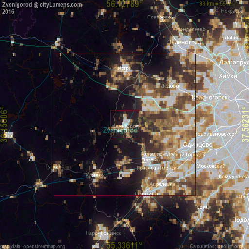
Analysis of Zvenigorod night lights 2016
Square area 10x10 km:
 4.19%
4.19%90-99
5.98%80-89
2.03%70-79
2.75%60-69
5.62%50-59
3.11%40-49
5.86%30-39
3.59%20-29
10.65%10-19
39.71%0-9
16.51%Square area 50x50 km:
5.05%90-99
6.21%80-89
3.27%70-79
3.99%60-69
5.47%50-59
5.34%40-49
5.89%30-39
5.2%20-29
6.52%10-19
10.89%0-9
42.18%Clear (daylight) street map image can be seen on geolist.org.
Map coordinates:
56° 7' 40.4" North, 36° 9' 21.8" East
55° 44' 2.4" North, 36° 51' 33" East
55° 20' 10" North, 37° 33' 44.3" East
Some cities around Zvenigorod sort by population:
• Krasnoznamensk
18.7 km =11.6 mi,  143°
143°
• Istra
20.7 km =12.9 mi,  1°
1°
• Dedovsk
22.2 km =13.8 mi,  47°
47°
• Kubinka
19.7 km =12.2 mi,  209°
209°
• Golitsyno
15.9 km =9.9 mi,  150°
150°
• Yershovo
3.9 km =2.4 mi, 0°
• Nikolina Gora
11.5 km =7.1 mi,  89°
89°
• Pavlovskaya Sloboda
16.6 km =10.3 mi,  57°
57°
461920 (p: 16,395)
Sources (retrieved 2019-11-25):
» Earth at Night: Flat Maps 2012, 2016