Golitsyno night lights from space
Night Light of Golitsyno (Moscow Oblast) from space (Russia) Src. Average luminocity for 10x10km area is 53.5652% and for 50x50km: 39.1292%.
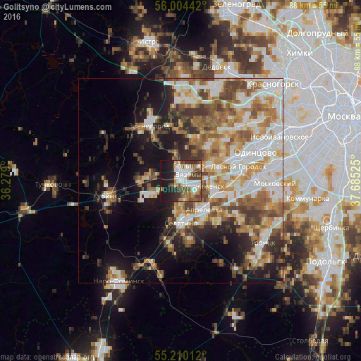
Analysis of Golitsyno night lights 2016
Square area 10x10 km:
 17.42%
90-99
7.77%80-89
4.64%70-79
5.01%60-69
5.89%50-59
7.27%40-49
10.28%30-39
8.27%20-29
11.03%10-19
22.43%0-9
0%Square area 50x50 km:
8.37%90-99
8.62%80-89
4.08%70-79
4.99%60-69
6.39%50-59
6.19%40-49
5.37%30-39
4.42%20-29
5.68%10-19
11.97%0-9
33.93%Clear (daylight) street map image can be seen on geolist.org.
Map coordinates:
56° 0' 15.9" North, 36° 16' 44.4" East
55° 36' 33.4" North, 36° 58' 55.6" East
55° 12' 36.4" North, 37° 41' 6.9" East
Some cities around Golitsyno sort by population:
• Krasnoznamensk
3.7 km =2.3 mi,  107°
107°
• Aprelevka
8.9 km =5.5 mi,  135°
135°
• Zvenigorod
15.9 km =9.9 mi,  330°
330°
• Selyatino
10.5 km =6.5 mi,  181°
181°
• Kokoshkino
11.8 km =7.3 mi,  96°
96°
• Vniissok
15.3 km =9.5 mi,  70°
70°
• Nikolina Gora
14.4 km =8.9 mi,  15°
15°
• Lesnoy Gorodok
14.6 km =9.1 mi,  76°
76°
560756 (p: 16,056)
Sources (retrieved 2019-11-25):
» Earth at Night: Flat Maps 2012, 2016