Yuzhno-Sukhokumsk night lights from space
Night Light of Yuzhno-Sukhokumsk (Dagestan) from space (Russia) Src. Average luminocity for 10x10km area is 4.7864% and for 50x50km: 0.2255%.
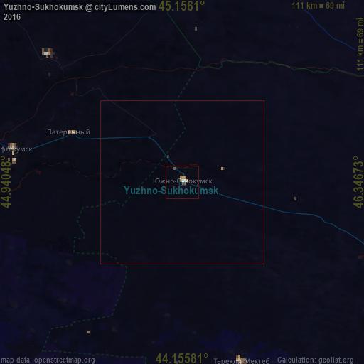
Analysis of Yuzhno-Sukhokumsk night lights 2016
Square area 10x10 km:
 0.76%
0.76%90-99
0.45%80-89
1.06%70-79
0.15%60-69
1.21%50-59
0.61%40-49
1.21%30-39
0.61%20-29
0%10-19
0%0-9
93.94%Square area 50x50 km:
0.03%90-99
0.02%80-89
0.04%70-79
0.03%60-69
0.05%50-59
0.02%40-49
0.05%30-39
0.02%20-29
0.04%10-19
0.01%0-9
99.68%Clear (daylight) street map image can be seen on geolist.org.
Map coordinates:
45° 9' 22" North, 44° 56' 25.7" East
44° 39' 29.2" North, 45° 38' 37" East
44° 9' 20.9" North, 46° 20' 48.2" East
Some cities around Yuzhno-Sukhokumsk sort by population:
• Neftekumsk
52.6 km =32.7 mi,  281°
281°
• Levokumskoye
79.7 km =49.5 mi, 283°
• Zaterechnyy
37.4 km =23.2 mi,  293°
293°
• Terekli-Mekteb
57.5 km =35.7 mi,  161°
161°
• Achikulak
64.9 km =40.3 mi,  259°
259°
• Kochubey
80.3 km =49.9 mi,  112°
112°
• Pravokumskoye
79.7 km =49.5 mi, 278°
• Komsomol’skiy
81 km =50.3 mi,  22°
22°
466060 (p: 10,665)
Sources (retrieved 2019-11-25):
» Earth at Night: Flat Maps 2012, 2016