Yur’yevets night lights from space
Night Light of Yur’yevets (Ivanovo) from space (Russia) Src. Average luminocity for 10x10km area is 1.5898% and for 50x50km: 0.5387%.
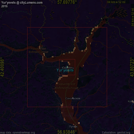
Analysis of Yur’yevets night lights 2016
Square area 10x10 km:
 0%
0%90-99
0%80-89
0%70-79
0%60-69
0%50-59
0.34%40-49
0.57%30-39
0.68%20-29
2.5%10-19
0%0-9
95.91%Square area 50x50 km:
0%90-99
0%80-89
0%70-79
0%60-69
0%50-59
0.01%40-49
0.04%30-39
1.13%20-29
0.38%10-19
0%0-9
98.44%Clear (daylight) street map image can be seen on geolist.org.
Map coordinates:
57° 41' 51.9" North, 42° 24' 3.5" East
57° 19' 12.3" North, 43° 6' 14.8" East
56° 56' 18.5" North, 43° 48' 26" East
Some cities around Yur’yevets sort by population:
• Kineshma
59.9 km =37.2 mi,  282°
282°
• Vichuga
71.6 km =44.5 mi,  260°
260°
• Chkalovsk
62.1 km =38.6 mi,  171°
171°
• Zavolzhsk
60.6 km =37.7 mi,  287°
287°
• Navoloki
70.2 km =43.6 mi, 283°
• Puchezh
38.1 km =23.7 mi, 174°
• Kovernino
47.7 km =29.6 mi,  116°
116°
• Sokol’skoye
20.2 km =12.6 mi, 170°
466258 (p: 11,488)
Sources (retrieved 2019-11-25):
» Earth at Night: Flat Maps 2012, 2016