Tyube night lights from space
Night Light of Tyube (Dagestan) from space (Russia) Src. Average luminocity for 10x10km area is 31.7841% and for 50x50km: 11.3367%.
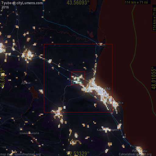
Analysis of Tyube night lights 2016
Square area 10x10 km:
 3.17%
3.17%90-99
9.68%80-89
3.02%70-79
1.27%60-69
3.17%50-59
2.86%40-49
4.6%30-39
2.7%20-29
16.98%10-19
27.14%0-9
25.4%Square area 50x50 km:
1.94%90-99
3.32%80-89
0.92%70-79
0.72%60-69
0.83%50-59
0.91%40-49
1.09%30-39
1.67%20-29
4.56%10-19
6.68%0-9
77.36%Clear (daylight) street map image can be seen on geolist.org.
Map coordinates:
43° 33' 39.3" North, 46° 36' 15.5" East
43° 2' 57.3" North, 47° 18' 26.7" East
42° 31' 59.8" North, 48° 0' 38" East
Some cities around Tyube sort by population:
• Makhachkala
17.8 km =11.1 mi,  117°
117°
• Leninkent
9.6 km =6 mi,  157°
157°
• Tarki
19.2 km =11.9 mi,  127°
127°
• Shamkhal
2.7 km =1.7 mi,  64°
64°
• Novyy Chirkey
24 km =14.9 mi,  301°
301°
• Korkmaskala
3 km =1.9 mi,  200°
200°
• Shamkhal-Termen
1.7 km =1.1 mi,  171°
171°
• Kyakhulay
16.9 km =10.5 mi, 122°
869342 (p: 6,466)
Sources (retrieved 2019-11-25):
» Earth at Night: Flat Maps 2012, 2016