Shamkhal night lights from space
Night Light of Shamkhal (Dagestan) from space (Russia) Src. Average luminocity for 10x10km area is 27.5333% and for 50x50km: 11.7728%.
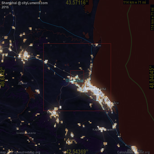
Analysis of Shamkhal night lights 2016
Square area 10x10 km:
 2.22%
2.22%90-99
6.83%80-89
3.02%70-79
1.27%60-69
2.54%50-59
2.86%40-49
3.65%30-39
2.38%20-29
18.73%10-19
26.03%0-9
30.48%Square area 50x50 km:
2.07%90-99
3.51%80-89
0.95%70-79
0.69%60-69
0.86%50-59
0.98%40-49
1.07%30-39
1.73%20-29
4.8%10-19
6.86%0-9
76.48%Clear (daylight) street map image can be seen on geolist.org.
Map coordinates:
43° 34' 16.2" North, 46° 38' 3.1" East
43° 3' 34.5" North, 47° 20' 14.4" East
42° 32' 37.3" North, 48° 2' 25.6" East
Some cities around Shamkhal sort by population:
• Makhachkala
16.3 km =10.1 mi,  124°
124°
• Leninkent
10.1 km =6.3 mi,  173°
173°
• Tarki
18.2 km =11.3 mi,  134°
134°
• Novyy Khushet
25.4 km =15.8 mi, 134°
• Novyy Chirkey
25.5 km =15.8 mi,  296°
296°
• Tyube
2.7 km =1.7 mi,  244°
244°
• Korkmaskala
5.3 km =3.3 mi,  221°
221°
• Kyakhulay
15.6 km =9.7 mi, 130°
495893 (p: 8,375)
Sources (retrieved 2019-11-25):
» Earth at Night: Flat Maps 2012, 2016