Temizhbekskaya night lights from space
Night Light of Temizhbekskaya (Krasnodarskiy) from space (Russia) Src. Average luminocity for 10x10km area is 0.1238% and for 50x50km: 2.8372%.
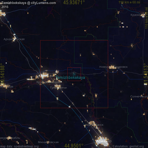
Analysis of Temizhbekskaya night lights 2016
Square area 10x10 km:
 0%
0%90-99
0%80-89
0%70-79
0%60-69
0%50-59
0%40-49
0%30-39
0%20-29
0%10-19
0.63%0-9
99.37%Square area 50x50 km:
0.24%90-99
0.42%80-89
0.21%70-79
0.39%60-69
0.32%50-59
0.43%40-49
0.46%30-39
0.45%20-29
0.49%10-19
3.32%0-9
93.28%Clear (daylight) street map image can be seen on geolist.org.
Map coordinates:
45° 56' 12.2" North, 40° 8' 30.8" East
45° 26' 44" North, 40° 50' 42" East
44° 57' 0.4" North, 41° 32' 53.3" East
Some cities around Temizhbekskaya sort by population:
• Kropotkin
21 km =13 mi,  267°
267°
• Gul’kevichi
15.6 km =9.7 mi,  229°
229°
• Novoaleksandrovsk
29.8 km =18.5 mi,  79°
79°
• Kavkazskaya
13.1 km =8.1 mi, 269°
• Grigoropolisskaya
23.4 km =14.5 mi,  134°
134°
• Girey
15.4 km =9.6 mi,  251°
251°
• Novoukrainskoye
25.7 km =16 mi, 253°
• Rasshevatskaya
20.6 km =12.8 mi,  45°
45°
483692 (p: 6,111)
Sources (retrieved 2019-11-25):
» Earth at Night: Flat Maps 2012, 2016