Solnechnyy night lights from space
Night Light of Solnechnyy (Khabarovsk) from space (Russia) Src. Average luminocity for 10x10km area is 0.865% and for 50x50km: 1.0632%.
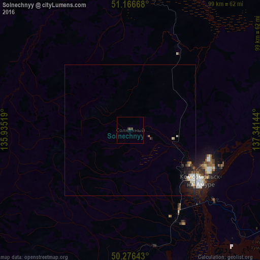
Analysis of Solnechnyy night lights 2016
Square area 10x10 km:
 0%
0%90-99
0%80-89
0%70-79
0%60-69
0%50-59
0.53%40-49
0.53%30-39
0.53%20-29
0.27%10-19
0.27%0-9
97.86%Square area 50x50 km:
0.15%90-99
0.25%80-89
0.09%70-79
0.07%60-69
0.08%50-59
0.11%40-49
0.13%30-39
0.15%20-29
0.38%10-19
0.95%0-9
97.63%Clear (daylight) street map image can be seen on geolist.org.
Map coordinates:
51° 10' 0" North, 135° 56' 6.7" East
50° 43' 25.2" North, 136° 38' 17.9" East
50° 16' 35.1" North, 137° 20' 29.2" East
Some cities around Solnechnyy sort by population:
• Khabarovsk
273.2 km =169.8 mi,  204°
204°
• Khabarovsk Vtoroy
276.3 km =171.7 mi, 203°
• Komsomolsk-on-Amur
32.5 km =20.2 mi,  126°
126°
• Amursk
56.8 km =35.3 mi,  162°
162°
• Chegdomyn
258.3 km =160.5 mi,  280°
280°
• Knyaze-Volkonskoye
265.1 km =164.7 mi, 198°
• Berëzovyy
125.1 km =77.7 mi,  327°
327°
• Khurba
39.3 km =24.4 mi,  153°
153°
2016307 (p: 14,227)
Sources (retrieved 2019-11-25):
» Earth at Night: Flat Maps 2012, 2016