Selyatino night lights from space
Night Light of Selyatino (Moscow Oblast) from space (Russia) Src. Average luminocity for 10x10km area is 50.9361% and for 50x50km: 31.7728%.
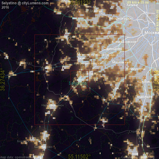
Analysis of Selyatino night lights 2016
Square area 10x10 km:
 7.89%
7.89%90-99
10.78%80-89
4.76%70-79
6.39%60-69
9.65%50-59
7.14%40-49
11.53%30-39
8.52%20-29
14.29%10-19
16.04%0-9
3.01%Square area 50x50 km:
6.44%90-99
6.61%80-89
3.41%70-79
4.27%60-69
4.85%50-59
4.71%40-49
4.16%30-39
3.7%20-29
5.62%10-19
12.05%0-9
44.19%Clear (daylight) street map image can be seen on geolist.org.
Map coordinates:
55° 54' 40.4" North, 36° 16' 27.6" East
55° 30' 54.5" North, 36° 58' 38.9" East
55° 6' 54.1" North, 37° 40' 50.1" East
Some cities around Selyatino sort by population:
• Krasnoznamensk
10.1 km =6.3 mi,  22°
22°
• Annino
19.3 km =12 mi,  66°
66°
• Kubinka
18.6 km =11.6 mi,  292°
292°
• Aprelevka
7.6 km =4.7 mi,  57°
57°
• Golitsyno
10.5 km =6.5 mi,  1°
1°
• Kokoshkino
15.2 km =9.4 mi,  52°
52°
• Kievskiy
11.8 km =7.3 mi,  216°
216°
• Lesnoy Gorodok
20 km =12.4 mi, 46°
497534 (p: 12,954)
Sources (retrieved 2019-11-25):
» Earth at Night: Flat Maps 2012, 2016