Selizharovo night lights from space
Night Light of Selizharovo (Tver’ Oblast) from space (Russia) Src. Average luminocity for 10x10km area is 0.1679% and for 50x50km: 0.0065%.
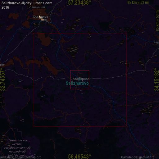
Analysis of Selizharovo night lights 2016
Square area 10x10 km:
 0%
0%90-99
0%80-89
0%70-79
0%60-69
0%50-59
0%40-49
0%30-39
0%20-29
0.48%10-19
0%0-9
99.52%Square area 50x50 km:
0%90-99
0%80-89
0%70-79
0%60-69
0%50-59
0%40-49
0%30-39
0%20-29
0.02%10-19
0%0-9
99.98%Clear (daylight) street map image can be seen on geolist.org.
Map coordinates:
57° 14' 3.8" North, 32° 44' 44.1" East
56° 51' 6.8" North, 33° 26' 55.3" East
56° 27' 55.5" North, 34° 9' 6.6" East
Some cities around Selizharovo sort by population:
• Rzhev
84.9 km =52.8 mi,  140°
140°
• Torzhok
94.2 km =58.5 mi,  76°
76°
• Nelidovo
81.3 km =50.5 mi,  210°
210°
• Ostashkov
38.7 km =24 mi,  327°
327°
• Kuvshinovo
48.1 km =29.9 mi,  65°
65°
• Andreapol’
75.4 km =46.9 mi,  252°
252°
• Peno
43.7 km =27.2 mi,  280°
280°
• Olenino
71.5 km =44.4 mi,  178°
178°
497661 (p: 7,096)
Sources (retrieved 2019-11-25):
» Earth at Night: Flat Maps 2012, 2016