Pervomayskoye night lights from space
Night Light of Pervomayskoye (Dagestan) from space (Russia) Src. Average luminocity for 10x10km area is 4.2524% and for 50x50km: 1.724%.
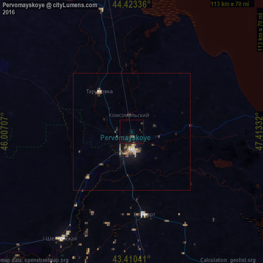
Analysis of Pervomayskoye night lights 2016
Square area 10x10 km:
 0%
0%90-99
0%80-89
0%70-79
0%60-69
0%50-59
0%40-49
2.22%30-39
0.79%20-29
0.79%10-19
8.25%0-9
87.94%Square area 50x50 km:
0.06%90-99
0.17%80-89
0.22%70-79
0.24%60-69
0.17%50-59
0.26%40-49
0.51%30-39
0.29%20-29
0.46%10-19
1.4%0-9
96.22%Clear (daylight) street map image can be seen on geolist.org.
Map coordinates:
44° 25' 24.1" North, 46° 0' 25.5" East
43° 55' 8.5" North, 46° 42' 36.7" East
43° 24' 37.5" North, 47° 24' 48" East
Some cities around Pervomayskoye sort by population:
• Kizlyar
8 km =5 mi,  177°
177°
• Babayurt
35.9 km =22.3 mi,  171°
171°
• Shëlkovskaya
54.5 km =33.9 mi,  213°
213°
• Aksay
64.4 km =40 mi,  199°
199°
• Kochubey
52.9 km =32.9 mi,  348°
348°
• Kargalinskaya
26.9 km =16.7 mi,  223°
223°
• Tarumovka
22.3 km =13.9 mi,  321°
321°
• Grebenskaya
51 km =31.7 mi, 212°
797213 (p: 9,073)
Sources (retrieved 2019-11-25):
» Earth at Night: Flat Maps 2012, 2016