Kargalinskaya night lights from space
Night Light of Kargalinskaya (Chechnya) from space (Russia) Src. Average luminocity for 10x10km area is 1.7955% and for 50x50km: 2.3462%.
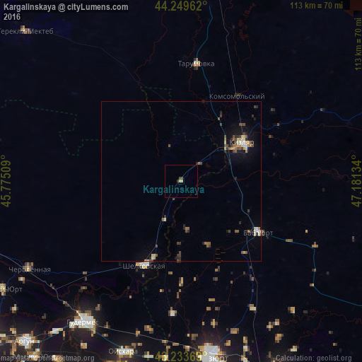
Analysis of Kargalinskaya night lights 2016
Square area 10x10 km:
 0%
0%90-99
0%80-89
0.61%70-79
0.61%60-69
0%50-59
0%40-49
1.06%30-39
0.76%20-29
0%10-19
0%0-9
96.97%Square area 50x50 km:
0.12%90-99
0.25%80-89
0.31%70-79
0.29%60-69
0.19%50-59
0.49%40-49
0.59%30-39
0.41%20-29
0.49%10-19
1.41%0-9
95.44%Clear (daylight) street map image can be seen on geolist.org.
Map coordinates:
44° 14' 58.6" North, 45° 46' 30.3" East
43° 44' 37.7" North, 46° 28' 41.6" East
43° 14' 1.3" North, 47° 10' 52.8" East
Some cities around Kargalinskaya sort by population:
• Kizlyar
22.2 km =13.8 mi,  58°
58°
• Babayurt
29 km =18 mi,  123°
123°
• Shëlkovskaya
28.5 km =17.7 mi,  202°
202°
• Pervomayskoye
26.9 km =16.7 mi,  43°
43°
• Aksay
41.4 km =25.7 mi,  183°
183°
• Engel’-Yurt
47.4 km =29.5 mi,  191°
191°
• Tarumovka
37.2 km =23.1 mi,  7°
7°
• Grebenskaya
25.2 km =15.7 mi, 199°
552500 (p: 5,371)
Sources (retrieved 2019-11-25):
» Earth at Night: Flat Maps 2012, 2016