Obolensk night lights from space
Night Light of Obolensk (Moscow Oblast) from space (Russia) Src. Average luminocity for 10x10km area is 3.2177% and for 50x50km: 8.8367%.
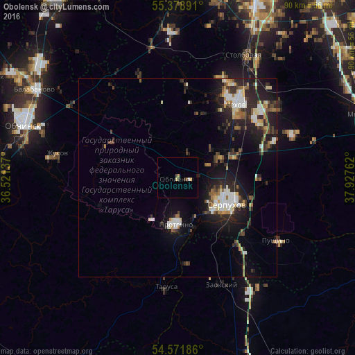
Analysis of Obolensk night lights 2016
Square area 10x10 km:
 0.24%
0.24%90-99
0.24%80-89
0.84%70-79
0.6%60-69
0%50-59
0.48%40-49
0.6%30-39
0.84%20-29
0.24%10-19
0.48%0-9
95.45%Square area 50x50 km:
1.18%90-99
1.61%80-89
0.91%70-79
0.73%60-69
0.91%50-59
0.91%40-49
1.11%30-39
1.64%20-29
3.75%10-19
6.58%0-9
80.66%Clear (daylight) street map image can be seen on geolist.org.
Map coordinates:
55° 22' 44.1" North, 36° 31' 16.9" East
54° 58' 38.7" North, 37° 13' 28.2" East
54° 34' 18.7" North, 37° 55' 39.4" East
Some cities around Obolensk sort by population:
• Serpukhov
13.7 km =8.5 mi,  119°
119°
• Chekhov
24.9 km =15.5 mi,  40°
40°
• Protvino
12.2 km =7.6 mi,  182°
182°
• Pushchino
29.4 km =18.3 mi, 122°
• Zhukovo
31.2 km =19.4 mi,  281°
281°
• Kremenki
12.2 km =7.6 mi,  213°
213°
• Tarusa
28.3 km =17.6 mi,  186°
186°
• Zaokskiy
29.6 km =18.4 mi,  156°
156°
6730265 (p: 5,264)
Sources (retrieved 2019-11-25):
» Earth at Night: Flat Maps 2012, 2016