Nikologory night lights from space
Night Light of Nikologory (Vladimir) from space (Russia) Src. Average luminocity for 10x10km area is 1.7165% and for 50x50km: 0.6956%.
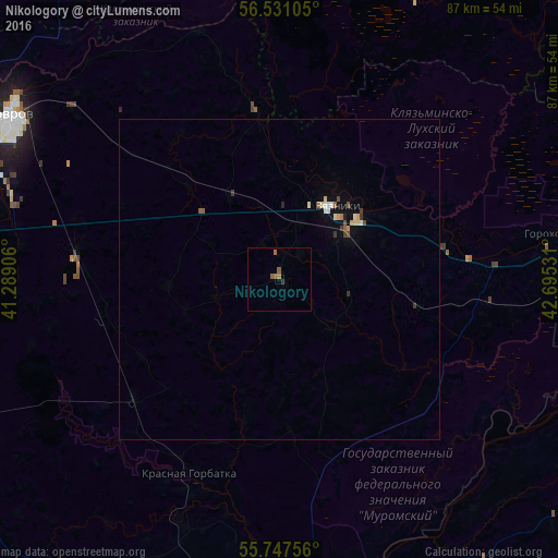
Analysis of Nikologory night lights 2016
Square area 10x10 km:
 0%
0%90-99
0%80-89
0%70-79
0%60-69
0.96%50-59
1.44%40-49
0%30-39
0.12%20-29
0.36%10-19
0%0-9
97.13%Square area 50x50 km:
0.04%90-99
0.11%80-89
0.1%70-79
0.05%60-69
0.1%50-59
0.15%40-49
0.08%30-39
0.12%20-29
0.07%10-19
0.08%0-9
99.09%Clear (daylight) street map image can be seen on geolist.org.
Map coordinates:
56° 31' 51.8" North, 41° 17' 20.6" East
56° 8' 28.7" North, 41° 59' 31.8" East
55° 44' 51.2" North, 42° 41' 43.1" East
Some cities around Nikologory sort by population:
• Kovrov
48 km =29.8 mi,  300°
300°
• Vyazniki
15 km =9.3 mi,  42°
42°
• Gorokhovets
43.9 km =27.3 mi,  81°
81°
• Krasnaya Gorbatka
33.3 km =20.7 mi,  205°
205°
• Melekhovo
45.8 km =28.5 mi,  289°
289°
• Talitsy
47.8 km =29.7 mi,  25°
25°
• Novovyazniki
12.7 km =7.9 mi,  60°
60°
• Mstera
26.8 km =16.7 mi,  350°
350°
521807 (p: 6,244)
Sources (retrieved 2019-11-25):
» Earth at Night: Flat Maps 2012, 2016