Nesterovskaya night lights from space
Night Light of Nesterovskaya (Ingushetiya Republic) from space (Russia) Src. Average luminocity for 10x10km area is 11.3864% and for 50x50km: 10.9212%.
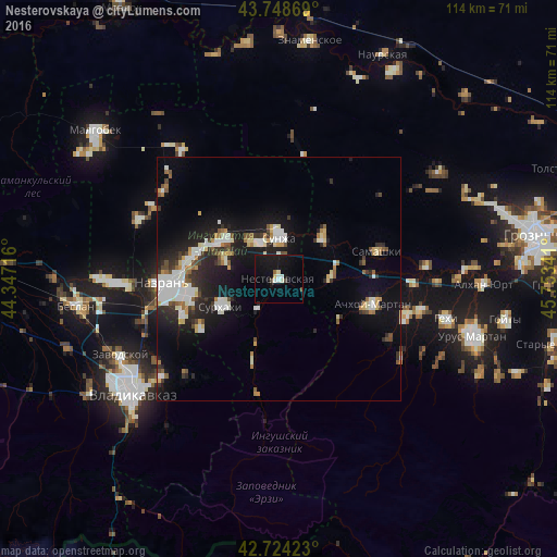
Analysis of Nesterovskaya night lights 2016
Square area 10x10 km:
 0.91%
0.91%90-99
2.58%80-89
1.06%70-79
0.3%60-69
0.61%50-59
0.91%40-49
1.52%30-39
0%20-29
0.3%10-19
22.12%0-9
69.7%Square area 50x50 km:
1.8%90-99
2.43%80-89
0.91%70-79
0.96%60-69
0.88%50-59
1.05%40-49
1.03%30-39
1.22%20-29
3.06%10-19
9.28%0-9
77.38%Clear (daylight) street map image can be seen on geolist.org.
Map coordinates:
43° 44' 55.3" North, 44° 20' 49.8" East
43° 14' 19" North, 45° 3' 1" East
42° 43' 27.2" North, 45° 45' 12.3" East
Some cities around Nesterovskaya sort by population:
• Sunzha
9 km =5.6 mi,  359°
359°
• Karabulak
14.3 km =8.9 mi,  301°
301°
• Troitskaya
9.3 km =5.8 mi,  324°
324°
• Surkhakhi
13.3 km =8.3 mi,  244°
244°
• Assinovskaya
10.7 km =6.6 mi,  88°
88°
• Sernovodsk
12.1 km =7.5 mi,  47°
47°
• Galashki
14.3 km =8.9 mi,  199°
199°
• Bamut
14.8 km =9.2 mi,  126°
126°
522470 (p: 19,186)
Sources (retrieved 2019-11-25):
» Earth at Night: Flat Maps 2012, 2016