Monino night lights from space
Night Light of Monino (Moscow Oblast) from space (Russia) Src. Average luminocity for 10x10km area is 39.2945% and for 50x50km: 35.693%.
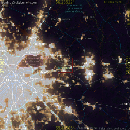
Analysis of Monino night lights 2016
Square area 10x10 km:
 3.01%
3.01%90-99
6.39%80-89
2.51%70-79
6.27%60-69
5.51%50-59
6.89%40-49
5.26%30-39
9.15%20-29
30.7%10-19
21.8%0-9
2.51%Square area 50x50 km:
10.56%90-99
8.36%80-89
3.35%70-79
3.49%60-69
3.61%50-59
3.12%40-49
3.18%30-39
5.45%20-29
8.96%10-19
9.42%0-9
40.5%Clear (daylight) street map image can be seen on geolist.org.
Map coordinates:
56° 14' 6.8" North, 37° 29' 25.8" East
55° 50' 32.8" North, 38° 11' 37" East
55° 26' 44.3" North, 38° 53' 48.3" East
Some cities around Monino sort by population:
• Zarya
11.5 km =7.1 mi,  212°
212°
• Losino-Petrovskiy
3.1 km =1.9 mi,  8°
8°
• Staraya Kupavna
3.9 km =2.4 mi,  192°
192°
• Elektrougli
13.2 km =8.2 mi,  175°
175°
• Kupavna
11.4 km =7.1 mi,  199°
199°
• Obukhovo
5 km =3.1 mi,  102°
102°
• Sverdlovskiy
8 km =5 mi,  339°
339°
• Imeni Vorovskogo
14.7 km =9.1 mi,  146°
146°
525396 (p: 19,852)
Sources (retrieved 2019-11-25):
» Earth at Night: Flat Maps 2012, 2016