Mga night lights from space
Night Light of Mga (Leningradskaya Oblast') from space (Russia) Src. Average luminocity for 10x10km area is 2.9242% and for 50x50km: 4.9174%.
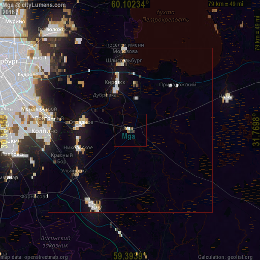
Analysis of Mga night lights 2016
Square area 10x10 km:
 0.43%
0.43%90-99
0.43%80-89
0.11%70-79
0.32%60-69
0%50-59
0.87%40-49
1.08%30-39
0.65%20-29
0.32%10-19
0.32%0-9
95.45%Square area 50x50 km:
0.75%90-99
0.9%80-89
0.52%70-79
0.65%60-69
0.38%50-59
0.22%40-49
0.32%30-39
0.45%20-29
1.29%10-19
4.77%0-9
89.76%Clear (daylight) street map image can be seen on geolist.org.
Map coordinates:
60° 6' 8.4" North, 30° 21' 48.8" East
59° 45' 0" North, 31° 4' 0" East
59° 23' 38" North, 31° 46' 11.3" East
Some cities around Mga sort by population:
• Kirovsk
15.1 km =9.4 mi,  344°
344°
• Otradnoye
14.3 km =8.9 mi,  282°
282°
• Nikol’skoye
16.7 km =10.4 mi,  250°
250°
• Shlissel’burg
22 km =13.7 mi,  355°
355°
• Imeni Morozova
25.2 km =15.7 mi, 356°
• Ul’yanovka
20.9 km =13 mi,  234°
234°
• Imeni Sverdlova
23 km =14.3 mi, 282°
• Priladozhskiy
19.5 km =12.1 mi,  45°
45°
527220 (p: 9,565)
Sources (retrieved 2019-11-25):
» Earth at Night: Flat Maps 2012, 2016