Krasnokumskoye night lights from space
Night Light of Krasnokumskoye (Stavropol’ Kray) from space (Russia) Src. Average luminocity for 10x10km area is 7.1182% and for 50x50km: 0.7106%.
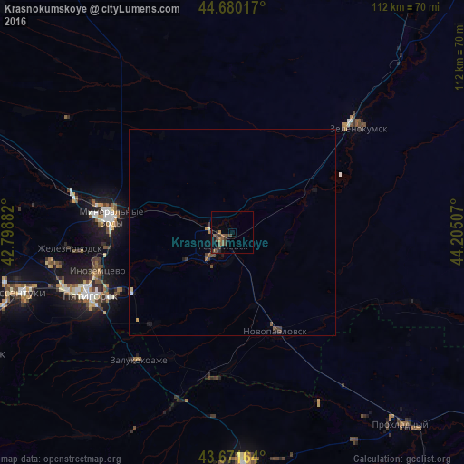
Analysis of Krasnokumskoye night lights 2016
Square area 10x10 km:
 0%
0%90-99
0%80-89
0%70-79
0.61%60-69
0.91%50-59
3.48%40-49
3.94%30-39
2.27%20-29
2.12%10-19
0.61%0-9
86.06%Square area 50x50 km:
0.01%90-99
0.02%80-89
0.04%70-79
0.07%60-69
0.12%50-59
0.2%40-49
0.28%30-39
0.25%20-29
0.12%10-19
0.2%0-9
98.67%Clear (daylight) street map image can be seen on geolist.org.
Map coordinates:
44° 40' 48.6" North, 42° 47' 55.8" East
44° 10' 41" North, 43° 30' 7" East
43° 40' 17.9" North, 44° 12' 18.3" East
Some cities around Krasnokumskoye sort by population:
• Georgiyevsk
3.9 km =2.4 mi,  221°
221°
• Nezlobnaya
10.3 km =6.4 mi,  229°
229°
• Soldato-Aleksandrovskoye
22.5 km =14 mi,  64°
64°
• Aleksandriyskaya
13.6 km =8.5 mi,  293°
293°
• Lysogorskaya
19.7 km =12.2 mi,  246°
246°
• Georgiyevskaya
7.5 km =4.7 mi,  185°
185°
• Novozavedennoye
14.4 km =8.9 mi,  49°
49°
• Podgornaya
6.4 km =4 mi,  295°
295°
542312 (p: 13,630)
Sources (retrieved 2019-11-25):
» Earth at Night: Flat Maps 2012, 2016