Khankala night lights from space
Night Light of Khankala (Chechnya) from space (Russia) Src. Average luminocity for 10x10km area is 54.3424% and for 50x50km: 19.7961%.
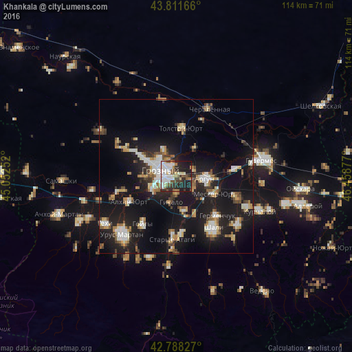
Analysis of Khankala night lights 2016
Square area 10x10 km:
 15.91%
90-99
13.64%80-89
4.39%70-79
2.42%60-69
3.33%50-59
8.48%40-49
6.06%30-39
8.79%20-29
16.97%10-19
19.7%0-9
0.3%Square area 50x50 km:
2.63%90-99
3.52%80-89
2.15%70-79
1.83%60-69
2.18%50-59
2.54%40-49
1.98%30-39
2.3%20-29
5.71%10-19
24.09%0-9
51.07%Clear (daylight) street map image can be seen on geolist.org.
Map coordinates:
43° 48' 42" North, 45° 3' 9.1" East
43° 18' 7.6" North, 45° 45' 20.3" East
42° 47' 17.8" North, 46° 27' 31.6" East
Some cities around Khankala sort by population:
• Groznyy
5.5 km =3.4 mi,  281°
281°
• Argun
9.6 km =6 mi,  93°
93°
• Mesker-Yurt
13.5 km =8.4 mi,  114°
114°
• Alkhan-Kala
18.2 km =11.3 mi,  254°
254°
• Alkhan-Yurt
16.8 km =10.4 mi,  242°
242°
• Staraya Sunzha
3.8 km =2.4 mi,  345°
345°
• Tolstoy-Yurt
16.1 km =10 mi,  6°
6°
• Chechen-Aul
11.7 km =7.3 mi,  166°
166°
865321 (p: 7,925)
Sources (retrieved 2019-11-25):
» Earth at Night: Flat Maps 2012, 2016