Kagal’nitskaya night lights from space
Night Light of Kagal’nitskaya (Rostov) from space (Russia) Src. Average luminocity for 10x10km area is 0.5521% and for 50x50km: 0.4826%.
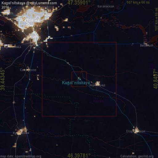
Analysis of Kagal’nitskaya night lights 2016
Square area 10x10 km:
 0%
0%90-99
0%80-89
0%70-79
0%60-69
0%50-59
0%40-49
0.45%30-39
0.6%20-29
0.15%10-19
0.6%0-9
98.21%Square area 50x50 km:
0.03%90-99
0.06%80-89
0.01%70-79
0.09%60-69
0.05%50-59
0.06%40-49
0.07%30-39
0.13%20-29
0.14%10-19
0.27%0-9
99.11%Clear (daylight) street map image can be seen on geolist.org.
Map coordinates:
47° 21' 32.4" North, 39° 26' 36.4" East
46° 52' 50" North, 40° 8' 47.7" East
46° 23' 52.1" North, 40° 50' 58.9" East
Some cities around Kagal’nitskaya sort by population:
• Bataysk
41.5 km =25.8 mi,  313°
313°
• Zernograd
12.9 km =8 mi,  107°
107°
• Samarskoye
35.4 km =22 mi,  280°
280°
• Mechetinskaya
26.5 km =16.5 mi,  117°
117°
• Kirovskaya
13.2 km =8.2 mi,  322°
322°
• Ol’ginskaya
37.3 km =23.2 mi,  336°
336°
• Novobataysk
27.8 km =17.3 mi,  274°
274°
• Starocherkasskaya
40.8 km =25.4 mi,  348°
348°
554482 (p: 6,848)
Sources (retrieved 2019-11-25):
» Earth at Night: Flat Maps 2012, 2016