Barič night lights from space
Night Light of Barič (Central Serbia) from space (Serbia) Src. Average luminocity for 10x10km area is 29.647% and for 50x50km: 26.6321%.
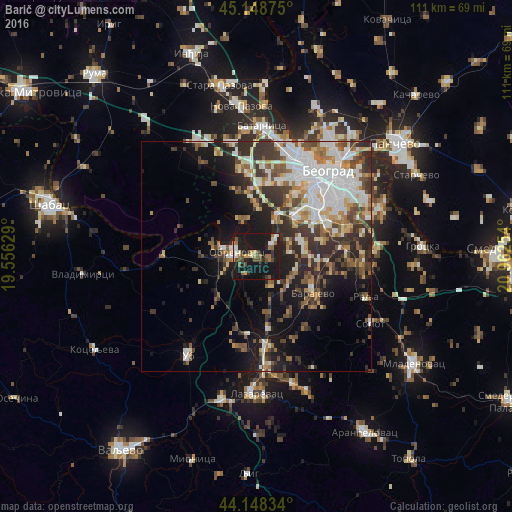
Analysis of Barič night lights 2016
Square area 10x10 km:
 1.97%
1.97%90-99
5.15%80-89
1.36%70-79
2.73%60-69
6.36%50-59
2.73%40-49
6.82%30-39
3.03%20-29
5.91%10-19
60.61%0-9
3.33%Square area 50x50 km:
5.41%90-99
5.73%80-89
2.25%70-79
2.41%60-69
3.22%50-59
3.86%40-49
3.83%30-39
5.06%20-29
6.64%10-19
13.17%0-9
48.4%Clear (daylight) street map image can be seen on geolist.org.
Map coordinates:
45° 8' 55.5" North, 19° 33' 22.6" East
44° 39' 2.5" North, 20° 15' 33.9" East
44° 8' 54" North, 20° 57' 45.1" East
Some cities around Barič sort by population:
• Belgrade
23.6 km =14.7 mi,  43°
43°
• Zemun
24.4 km =15.2 mi,  27°
27°
• Sremčica
10.9 km =6.8 mi,  74°
74°
• Obrenovac
4.7 km =2.9 mi,  275°
275°
• Surčin
15.9 km =9.9 mi,  5°
5°
• Dobanovci
19.7 km =12.2 mi,  352°
352°
• Umka
4.7 km =2.9 mi,  49°
49°
• Zvečka
7.6 km =4.7 mi,  261°
261°
792866 (p: 5,033)
Sources (retrieved 2019-11-25):
» Earth at Night: Flat Maps 2012, 2016