Lunguleţu night lights from space
Night Light of Lunguleţu (Dâmboviţa) from space (Romania) Src. Average luminocity for 10x10km area is 3.55% and for 50x50km: 5.4658%.
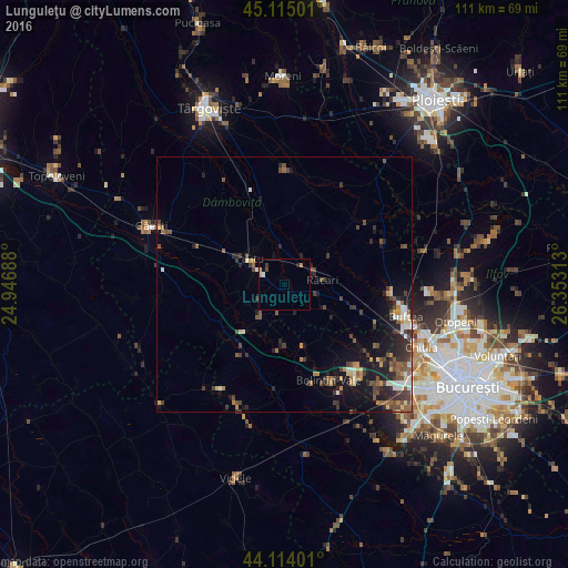
Analysis of Lunguleţu night lights 2016
Square area 10x10 km:
 0.45%
0.45%90-99
0.15%80-89
1.21%70-79
0%60-69
0.61%50-59
0%40-49
0.61%30-39
0.61%20-29
0.61%10-19
0.45%0-9
95.3%Square area 50x50 km:
0.4%90-99
0.67%80-89
0.51%70-79
0.51%60-69
0.63%50-59
0.98%40-49
1.52%30-39
1.33%20-29
1.88%10-19
3.86%0-9
87.71%Clear (daylight) street map image can be seen on geolist.org.
Map coordinates:
45° 6' 54" North, 24° 56' 48.8" East
44° 37' 0" North, 25° 39' 0" East
44° 6' 50.4" North, 26° 21' 11.3" East
Some cities around Lunguleţu sort by population:
• Titu
9.9 km =6.2 mi,  291°
291°
• Potlogi
9.1 km =5.7 mi,  215°
215°
• Corbii Mari
14 km =8.7 mi,  238°
238°
• Răcari
6.8 km =4.2 mi,  74°
74°
• Găiseni
11.3 km =7 mi,  181°
181°
• Ciocăneşti
15.9 km =9.9 mi,  96°
96°
• Odobeşti
6.6 km =4.1 mi,  270°
270°
• Tărtăşeşti
13.6 km =8.5 mi,  108°
108°
674307 (p: 5,718)
Sources (retrieved 2019-11-25):
» Earth at Night: Flat Maps 2012, 2016