Recaş night lights from space
Night Light of Recaş (Timiş) from space (Romania) Src. Average luminocity for 10x10km area is 4.2202% and for 50x50km: 5.708%.
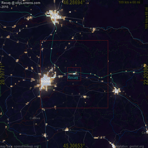
Analysis of Recaş night lights 2016
Square area 10x10 km:
 0.89%
0.89%90-99
0.3%80-89
0%70-79
0%60-69
0.74%50-59
1.34%40-49
0.89%30-39
1.19%20-29
0.6%10-19
1.49%0-9
92.56%Square area 50x50 km:
1.62%90-99
0.98%80-89
0.4%70-79
0.45%60-69
0.49%50-59
0.58%40-49
0.74%30-39
0.91%20-29
1.92%10-19
2.81%0-9
89.1%Clear (daylight) street map image can be seen on geolist.org.
Map coordinates:
46° 17' 13" North, 20° 47' 51.8" East
45° 47' 56" North, 21° 30' 3" East
45° 18' 23.5" North, 22° 12' 14.3" East
Some cities around Recaş sort by population:
• Timişoara
21.9 km =13.6 mi,  256°
256°
• Lugoj
33.5 km =20.8 mi,  111°
111°
• Buziaş
18.5 km =11.5 mi,  154°
154°
• Vinga
33.6 km =20.9 mi,  316°
316°
• Săcălaz
30.5 km =19 mi, 261°
• Giarmata
15.4 km =9.6 mi,  286°
286°
• Sânandrei
26.5 km =16.5 mi,  283°
283°
• Jebel
35.1 km =21.8 mi,  219°
219°
669058 (p: 8,508)
Sources (retrieved 2019-11-25):
» Earth at Night: Flat Maps 2012, 2016